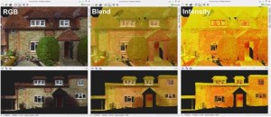
If you want to have full control over the survey data we provide, McCarthy Taylor’s LSS software can now help.
The update which costs an extra £250 per year, allows the user to handle point cloud data at a very low cost. Aims believes this can change the market quite drastically in favour of our customers.
 Laser Scanners and Unmanned Aerial Vehicles have become commonplace within the field of land survey. However, the costs involved in purchasing a scanner or UAV, the processing software and insurance can be phenomenal. Seeing as we have already fronted this cost for our company, we have created a new, attractive and flexible pricing structure based on you, as the client, processing the data.
This new workflow works for many different applications. Whether you need to measure volumes, complete a visual impact assessment or create a topographical survey drawing, access to the raw point cloud data can let you get the information you need, when you need it.
Worried about how hard it is to learn new software? The promotional material from McCarthy Taylor themselves best describes how easy it is to use:
“You import ASCII XYZ, PTS, LAS or E57 files to create a point cloud database with or without RGB and Intensity. Open up an empty LSS survey and start immediately digitising in 3D from the point cloud. While the LSS program is dongle protected, the point cloud program isn’t, so in standalone mode it can be used to create new point cloud databases, merge point clouds together and to visualise them, all without LSS. If you’re wanting to import a 1 billion point file and don’t want it to impede your work on something else, you can run it on a spare computer, set off several conversions at once and simply leave it to chunter away uninterrupted.”
We believe it will come as a bit of a revelation when you realise how efficient and simple it is to use!
LSS Point Cloud is still in Beta.
